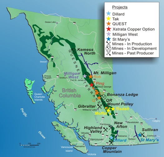
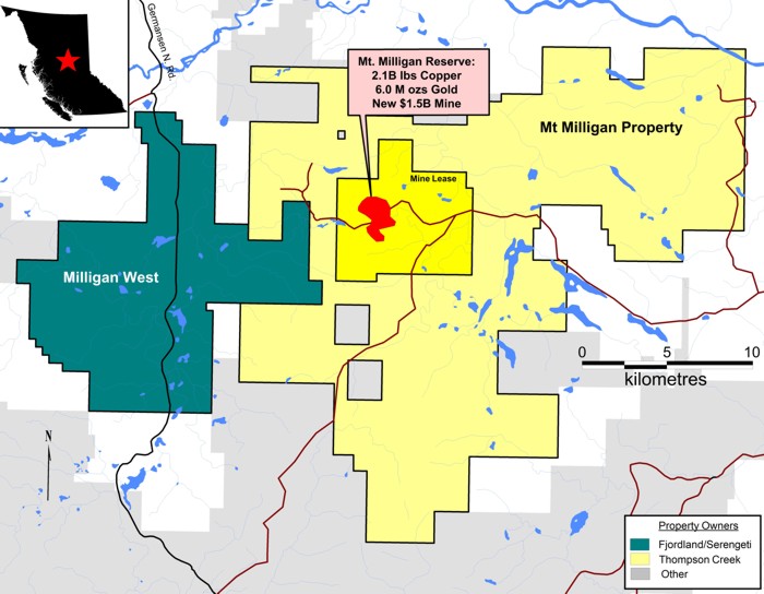
The Milligan West Property (15,736 ha) is located 160 km northwest of Prince George, strategically situated adjoining the western boundary of Thompson Creek Metals Ltd Mt Milligan copper-gold project. The Mt. Milligan mine, in production since late 2013, has reported the following mineral endowment as at December 31, 2016 (Centerra Gold Inc. Annual Report 2016) ;
GOLD - Proven and probable mineral reserves total 5.8 million ounces of contained gold (496.2 Mt at 0.4 g/t gold)
COPPER - Measured and indicated mineral resources total an estimated 718 million pounds of contained copper (243.9 Mt at 0.133% copper).
Access to the Milligan West property is via the all-weather gravel North Road 80 km north of from Fort St James. The North Road accesses an extensive network of logging roads in north-central BC. A network of logging roads accesses the southern half of the Milligan West claim and from the east on forestry access roads to the Mount Milligan mine site. From Mount Milligan, a trail travels westward to Heidi Lake and to the edge of the Milligan South Property limits. The northern portion of the property is crossed by old trails that have been decommissioned. Other areas are accessible by helicopter and/or construction trails off existing roads. As of 2016, a large cut block has opened up much of the western Heidi Lake area of the property.
Exploration for porphyry copper and copper-molybdenum exploration in the Nation Lakes area was conducted in the 1960s and 1970s and government airborne geophysical surveys were completed in the 1960s. During the 1980s exploration focused on structurally controlled precious metal deposits typically found near the Pinchi Fault, located west of the property. The discovery and definition of the Mt. Milligan deposit by Continental Gold Corp. and Placer Dome led to a significant amount of base and precious metal exploration in the surrounding area during the late 1980’s and early 1990’s.
In 2005, AMARC covered portions of the property with wide spaced, 50 m dipole IP lines. This survey outlined a +20 km long system of chargeability and magnetic anomalies. This survey had a shallow depth penetration (~150 m max) and the anomalies were open to increasing in strength with depth.
Serengeti Resources and Fjordland formed a Joint Venture in 2013 and carried out IP surveys, soil sampling and a small drilling program. The property sat largely dormant since 2009 with the exception of some geochemical sampling in the Heidi Lake West area and until 2016 when a deep penetrating IP survey was completed in the Heidi Lake West area.
The Milligan West property lies in the central part of the Upper Triassic to Lower Jurassic Quesnellia Terrane. The term Quesnel Trough is commonly applied to this belt, which is comprised of a belt of Lower Mesozoic volcanic rocks and intrusions that lies between highly deformed Proterozoic and Paleozoic strata to the east, and deformed Upper Paleozoic strata to the west. The Quesnel Trough is the host of numerous alkalic and calc-alkalic porphyry copper-gold deposits within British Columbia.
The Milligan property encompasses two large regional-scale aeromagnetic highs that are generally trending in a northwesterly direction. One linear trend passes through the East Area, northwesterly to the Nation River. A larger and stronger magnetic anomaly extends from the south of the property through the Main Area and extends through the Northwest Area, westerly to Witch Lake. A circular moderate magnetic anomaly, projecting southwesterly to the West Area, appears related to the Main-Northwest anomaly.
Rocks found in outcropping (to the west of the property), and diamond drilling form the basis of the property geology. Outcrops exposed along the northeast flowing tributary of Wittsichica Creek are composed of feldspar porphyries and iron-stained Takla Group fragmental volcanics. Exposures in the higher areas near the southern property boundary have been mapped as augite porphyry flows, lapilli tuffs and epiclastics sediments of the Takla Group Witch Lake Formation. Dominant faulting directions were interpreted to be northwest, southeast and northeast-southwest with a lesser east-west component. Drilling in the Main area intersected porphyritic plagioclase-augite andesitic breccias, minor tuffs, and massive flows, intruded by microgabbro dykes. Strong propylitic alteration is dominant with minor phyllic and potassic evident.
Two shallow holes drilled at the same time as the earlier IP survey in the Heidi West area encountered sedimentary rocks, cut in one of the holes by Milligan age, propylitically-altered monzodioritic sills with increasing pyrite to the bottom of the hole and one interval assaying 0.15 g/t Au over 9 meters.
Cu-Au at Mt. Milligan occurs in both intrusive and volcanic rocks, largely hosted by qtz vein stockworks with high Au:Cu ratios. The Milligan West property hosts exellent exploration potential for alkalic Cu-Au porphyry and porphyry-related targets. It is situated in a highly favourable tectonic setting within the 60 km long E-W trending flexure anchored by the Mt. Milligan deposit to the east.
Several regional magnetic and radiometric anomalies exist within the Milligan West property, similar to those associated with Mt. Milligan. Milligan West contains regional magnetic highs similar to Mt. Milligan, where highest grades are located peripheral to a magnetite-rich stock. These mag highs also coincide with IP and resistivity highs.
Previous work on the Mil property includes airborne magnetic, ground induced polarization (IP) surveys, geochemical soil surveys, as well as three shallow diamond drill holes totaling 790 metres in 2009. Drilling tested a very small proportion of a very large (22 kilometres by 2 - 3 kilometres) coincident IP chargeability and magnetic anomaly. One drill hole bottomed in a strongly altered zone that assayed 0.15% Cu over the final 6 metres. In addition, soil survey results yielded coincident copper and gold anomalies. Additional drilling is warranted.
Previous work on Milligan South included airborne magnetic, ground IP surveys, geochemical soil surveys, as well as two very shallow diamond drill holes totaling 230 metres by a previous operator. Drilling tested two of three separate, coincident magnetic and IP anomalies, along with coincident copper and gold soil anomalies. The Company believes that the drilling may not have intersected the target and that additional drilling is warranted.
Fjordland and Serengeti have compiled all previous exploration data for the Mil and Milligan South properties into a single database for the Milligan West Property.
During September 2016 Serengeti undertook an IP survey consisting of a deep penetrating line down the east boundary looking for an analogue of the Mount Milligan deposit 4.5 km east of the boundary.
This survey identified a large chargeability anomaly. Fjordland did not participate in this program and was consequently diluted to a 43.7% interest.
In September 2017, Fjordland joined Serengeti in drilling 1,256 metres in three holes targeting zones identified by interpretation of the 2016 Induced-Polarization (IP) survey data, earlier property-wide geophysical surveys, and short drill holes completed by previous workers. Encouraging results were intersected within skarnified volcaniclastic tuff and feldspar-porphyry dykes, including 1.12 git gold, 0.70 git silver and 0.14% copper over 2.0 metres in MW-17-02, with maximum gold and silver values reaching 1.57 git over 1.5 metres, and 33.50 git over 3.1 metres, respectively.
The 2017 Milligan West program added significantly to the understanding of the local geology and has led to the identification of an untested near-surface geophysical target area approximately one kilometre to the north of the 2017 drill holes. The newly identified geophysical target area is coincident with historical copper-, zinc- and gold-in-soil geochemical anomalies, which lie directly on trend with the Mt. Milligan - Heidi Lake sulphide system to the east. Although the nature of mineralized intercepts from 2017 are discontinuous, the program confirmed that mineralization at Milligan West is associated with hydrothermal intrusive activity, and Fjordland remains optimistic in the potential for the property to host a significant mineralized system.
Notable intersections from the 2017 drilling program as well as associated geological observations are included here
Note: John Peters, PGeo is the QP who has reviewed the data presented.
Last update on April 13, 2018